On Thursday and Friday before leaving, I told some people I was going to climb Mount Adams that weekend. "Oh... Where's that?" was the most common reply. Which is crazy because at 12,281 feet, it is the state's second highest mountain, after the much more famous Mount Rainier. I realized that unlike Mount Baker, Mount Rainier, and Mount St. Helens, Mount Adams is not visible from the highway so many Washingtonians have no idea where it is. In fact, the only times I've ever seen it have been from the air, before landing at Sea-Tac airport on a clear day.
Yes, it is wayyy down there, almost to Portland and much farther east. Even driving there is tricky, because the shortest route is on backroads, even down to unpaved forest service roads. If you want to stick to the faster freeway route you can go to Oregon and Hood River, but that adds 100 miles.
Matt and I opted for shorter, slower, and scenic. We left after work on Friday, and after getting through city traffic, stopping for dinner, and driving on wash-boarded back-roads in the fog, we didn't reach our Trout Lake hotel until after 10:30pm. We repacked our bags for the hike the following day and went to bed around midnight.
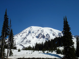
We had originally planned to do the climb as a 2-day backpack- arrive Saturday, hike up about 3,000 feet to a campsite, stay the night, summit on Sunday, then hike out. Unfortunately, the weather forecast for Sunday was looking pretty bad, so we decided to do the whole hike in on Saturday. We woke up at 5am Saturday morning, got permits, and drove to the trailhead. As we passed this view of the mountain, I couldn't help but be amazed that it was actually possible to climb in one day. Really?! We are going to be on top of that?!
We did the South climb from the Cold Springs trailhead which starts at 5,600 feet. There was no snow on the trail for the first 15 minutes or so, and then we came out of the trees onto snow into bright sunlight and a clear morning. The idea was to ascend about 6,600 vertical feet to reach the summit- the most elevation gain of any day hike I've ever done. I was determined to not make the same mistake I made last time I hiked on a snow field to Camp Muir- sunburning my ears. I slathered them with sunscreen AND covered them with a bandana. (Fool me twice, shame on me!)
I had brought a large black plastic garbage bag and made myself a glissade diaper, partly to protect my pants and partly to go faster. In some sections it wasn't steep enough to glissade, but for the most part it was a quick and and absolutely giddy slide down the mountain.
Slowly but surely we pushed upward, checking the altimeter as we shaved thousands of feet off the hike. We thought we might need crampons, but the snow was so soft that they weren't necessary. It was a beautiful day and we had sweeping views of Mount Hood, Mount Saint Helens, foothills, and the dry expanse of eastern Oregon. There were great campsites along the way, on exposed soil nestled between rocks.
After the Lunch Counter camping area at about 9,500 feet is when the trail started getting really steep. And it was over 10,000 feet that I started to feel the altitude. It was a slow, sometimes meditative, sometimes discouraging tromp up. At that point you see what looks like the summit, but it's actually a false summit. We finally reached the false summit around 3pm and stopped to rest on some rocks. A lot of other people were hanging out there, some on there way up, some on their way down. We could see the real summit, over a mile away and about 700 more vertical feet.
Unfortunately, it was already sort of late in the day. We were tired, and we figured that by the time we made it to the summit and back down, we wouldn't get off the trail til after 9. I really really really wanted to reach the top, but the smarter decision was to listen to our bodies and limited daylight. It was still a phenomenal hike and I would just have to come back someday, either climbing it as a backpack, or camping at the trailhead and waking up much earlier. For now I was just happy to enjoy the amazing glissade back down. Where it was really steep there were fast, established runs and of course stellar views.
It still takes effort to get back down though- to pick a good chute, maneuver curves, hold your feet up. Sometimes when I got going too fast I used my ice axe as a brake, and sometimes when I was going slow I used it as a paddle to push myself. Unfortunately, at one point I didn't make a wide enough arch with the axe and ended up stabbing myself in the leg. It tore my pants but it didn't hurt that bad and I didn't think much of it.
We made it off the mountain tired but very happy, and the next day had a mellow day exploring the area. The mountain mingles with the Gifford Pinchot National Forest, which has tons of great hikes, lakes, waterfalls, lava formations, ice caves, and huckleberries. The berries were just getting ripe and you can find different varieties in the same patch of forest! It was a great weekend and I even had an ice axe souvenir to take home with me.


