"Just so you know, there is no water going over Cathedral Pass for about 7 miles. Fill up as much as you can at Daniel Creek," the man tells us.
"Thanks!" We offer, "The footbridge is out at Lemah Creek, but there is an easy crossing on a log just downstream."
And so a typical conversation might go with other hikers we passed, as Max and I made our way for six days down the trail. In the backcountry with no phones or internet, old-fashioned word of mouth was our most valuable communication tool. We had detailed maps, but of course a map cannot tell you that it's been a dry year and a certain creek isn't running right now, or how murky the glacial tarns might be looking, or whether people are already at a certain campsite.
There are several hundred people per year that hike the Pacific Crest Trail in its entirety, through the mountains from Mexico to Canada. They typically leave in April, with the faster ones just now getting into the central and northern Cascades of Washington state. When Max and I decided a couple months ago to backpack the section of the Pacific Crest Trail from Snoqualmie Pass to Steven's Pass, we didn't think of ourselves as "section hikers". We had just heard that it was a beautiful section of trail, and happened to be a distance (74 miles) that we wanted to do. But as the days went on and we met other hikers doing anywhere from dozens to hundreds to thousands of miles, we realized that we too were a small part of that big community.
Since most hikers are coming from the south, they naturally go from Snoqualmie Pass to Steven's Pass, known as Section J of the PCT. However, we decided to start at Steven's instead, partly to go against the grain, and partly to finish closer to Seattle in case anything were to go wrong. This ended up working out great for us. It was fun to pass so many thru-hikers and section-hikers, and get an idea of who was doing the trail.
We met local residents, hikers from around the U.S., Europeans, couples, solo hikers, friends, and parent-child duos. We passed a total of 117 backpackers, or approximately 20 per day. I wouldn't exactly call the trail busy, but it is definitely well-used this time of year as it is late enough that the snow has melted, but early enough that it's still warm and dry. We were lucky to get really nice weather the whole time, a mix of sunny and partial clouds, and only one night of rain.
Okay, pictures! Here's what we did each day...
Day 1: Steven's Pass to Trap Pass
Even though you start the hike walking under the chair lifts of ski resort, it's only a few miles until you feel worlds away.
The trail is in the Alpine Lakes Wilderness, and true to its name, you pass many alpine and sub-alpine lakes of various sizes. Here is Josephine Lake on our first sunny morning.
We passed Trap Lake and climbed steeply up to Trap Pass where there is one campsite with sweeping views to the east and west before the trail descends back down the other side. We camped there the first night with a ton of mosquitoes, but luckily didn't have too many bugs to deal with the rest of the trip.
Day 2: Trap Pass to Daniel's Creek
We started the day with a nice downhill to Surprise and Glacier Lakes.
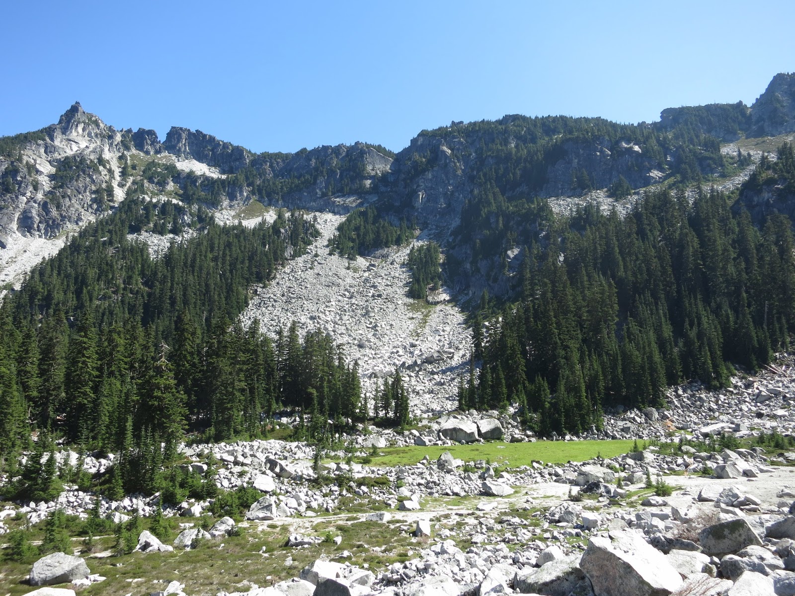
Then it was a steep uphill again over the scree and out of this valley over Piper Pass. Here's Max partway up looking back down at Glacier Lake with a view of Glacier Peak in the distance.
We had lunch at the top of the pass, tired and sweaty. I had put my trekking poles point-up strapped to the outside of my pack, and when I hoisted up my pack, I accidentally stabbed a pole into my thigh. Luckily that was the worst injury incurred on the whole trip.
We switchbacked down the other side of the mountain, partway down reaching Deception Lake where we had a beautiful and refreshing swim.
We kept descending, all the way down to 3,500 feet into the Daniel's Creek river valley. Did I mention that every day the trail gains and loses 3,000 to 4,000 feet of elevation? It's a constant up and down.
Day 3: Daniel's Creek to Waptus River
Daniel's Creek is also known as "the ford" as it's a bit tricky to cross and impassible for stock. We had been warned of its sketchiness, but luckily it wasn't too hard.
We were happy to start today's climb in the cool of the morning, and when we weren't too tired yet. Here you can see Cathedral Rock, which is a popular rock climbing destination. We went up over Cathedral Pass....
... and then down the steep switchbacks of the other side...
... and had lunch at Deep Lake in the shadow of Cathedral.
We continued on into the Waptus River valley, which was pretty much the only flat section of the entire trail. We set up camp near the river and made dinner, then drank some bourbon hot chocolates before calling it a night.
Day 4: Waptus River to Lemah Creek
Again, we planned nicely to do the big climb of the day in the morning. We got up above Waptus Lake and then over Escondido Pass.
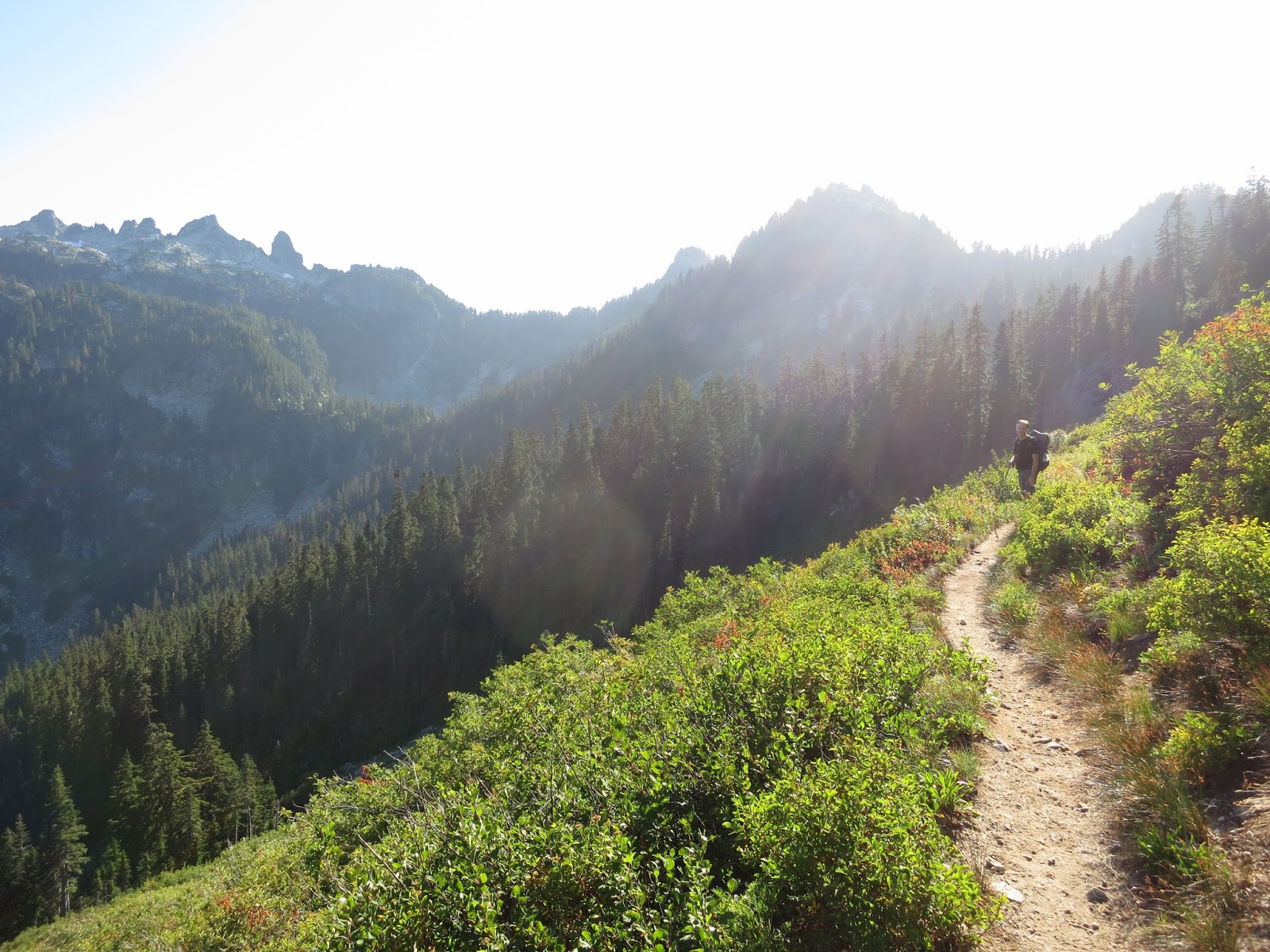
I really like to be able to see the trail ahead, which we could as we traversed Escondido Ridge. You can just make out the trail here.
We stopped for lunch on the ridge before continuing into a section with remnants of a 1994 forest fire. It was eerily beautiful to walk through the ghostly white trunks, black char, and bright pink fireweed.
At the bottom, we reached the Lemah River valley. Just before our low point in the meadow, I spotted a bear. We had a chance to watch the huge brown-colored black bear traipse around for a bit before we continued on, talking loudly to make our presence known.
The footbridge was totally missing at Lemah Creek, but we were able to cross anyway and find a nearby campsite to call home.
Day 5: Lemah Creek to Ridge Lake
It was uphill again, through another burn, past more lakes, and over waterfalls.
We had heard Spectacle Lake was indeed spectacular, and like good hobbits we planned to have second breakfast there. Max's cup is also a thermos, so we had hot coffee and snacks overlooking the most stunning lake of the trip.
Here's the lake again, from a little higher. Seriously, if you ever have 3 or 4 days, try to get to Spectacle Lake. It's about 19 miles north of Snoqualmie Pass. Even though the whole trip was beautiful, this section after Spectacle was definitely the most wild, rugged, and impressive.
We went down a little into Park Lakes basin, then back up over another ridge.
This was another ridge traverse, skirting Chikamin, Huckleberry, and Alaska Mountains, and looking way across to Joe Lake.
The clouds rolled in and the wind picked up, but that didn't stop us from having a lunch picnic on the side of the trail. Max and I realized that the only pictures we had taken of us together were selfies, so we asked a passerby to take our picture. He was a middle-aged man in a brand new and huge Gregory packpack and
Stergis cap. In answer to our request, he said, "Shit, this is more than a 15% grade!" Then, "You guys seen any hunters? I hope I don't come across no one with a gun out here." He finally took our picture. We both squinted at our upcoming trail section, as he would go up and over a pass, and we'd go down over scree. "Do we pass that Joe Lake?" we asked. "Dunno," he replied. "All these lakes look the same to me!" He was awesome.
Here you can see the trail go right through the scree field. This was the slowest day of hiking, because the trail was pretty rough. It took us longer today to go 13 miles than yesterday going 15.
On the plus side, I convinced a pika and a marmot to pose for pictures.
We finally made it to Ridge Lake and found a site with a great westward view. It was a little strange to be camped somewhere with so many other people around, as Ridge Lake is only 8 miles from Snoqualmie and it was a Saturday night. Max whipped up some delicious glass noodles and veggies in a coconut peanut curry before we collapsed onto our thermarests exhausted.
DAY 6: Ridge Lake to Snoqualmie Pass
Since we only had 8 miles to hike and it was all downhill, we had a pretty mellow day. We slept in and drank our coffee slowly at our little campsite. I soaked my feet in the cool water of Ridge Lake. I washed my face and combed my hair and tried to look somewhat presentable since we were no longer passing only thru-hikers, but casual, nice-smelling day hikers.
We got a nice view of Mount Rainier toward the end of the trail. Seeing this familiar sight made me feel like I was almost home, like I had made it. The trail spit us out right near I-90, and it was a short walk into commercial Snoqualmie Pass. It was strange, to have been somewhere so rugged just 24 hours before, then to suddenly find myself at a Chevron station. But we embraced the front country with a late lunch at a delicious food cart, and a cold beer. Then I turned on my cell phone for the first time in a week and called our ride to pick us up.


1 comment:
Damn, girl! I know better than to be impressed by your physical prowess - there's nothing you can't do - but this time I'm ogling your memory. I would never, EVER know the names of each peak and lake I passed, much less remember them. Glad you two had such a lovely time!
Post a Comment